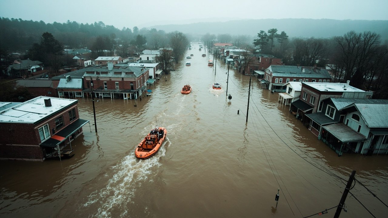
Record Flooding Hits North Georgia and Southern Tennessee
A catastrophic flood event has forced evacuations and water rescues in McCaysville, Georgia, and Copperhill, Tennessee, after overnight rainfall pushed the Ocoee River and Toccoa River above levels recorded in 1990. Flash flood emergencies are in effect for both communities, according to CNN's reporting on the event.
McCaysville Police Chief Michael Earley confirmed the severity of conditions in a social media post, warning residents: "DO NOT DELAY YOUR EVACUATION. LEAVE THE AREA NOW." Earley added that his department was "actively trying to water rescue people" and that numerous residents remained trapped in their homes.
Rainfall That Breaks Historical Records
The National Weather Service reported that 3 to 6 inches of rain fell overnight across North Georgia, with isolated areas receiving more than 8 inches. According to CNN, meteorologists characterized the rainfall rate as a frequency unlikely to occur more than once every 200 years — placing this event in an extreme statistical category rarely seen in the region's recorded history.
The saturated ground left rivers with little capacity to absorb additional runoff, causing rapid and dangerous rises in water levels across both Tennessee and Georgia communities. Officials warned that dangerous river flooding would persist even after the heaviest rain moved out of the area.
Evacuations and Water Rescues Underway
Emergency personnel in McCaysville conducted approximately 30 water rescues using boats, as streets in the downtown core were submerged under 6 to 7 feet of standing water in some locations. Areas along West and East Tennessee Avenue were among those reported as heavily inundated, with buildings surrounded by floodwaters.
The Fannin County Emergency Management Agency coordinated rescue operations and acknowledged that while some residents had been reached, numerous others still required evacuation. The Fannin County Fire Rescue worked continuously alongside other agencies to manage the crisis, according to WTAE's coverage of the event.
McCaysville declared a formal state of emergency and effectively closed the city until further notice. Local officials from both Fannin and Gilmer Counties urged the public to comply with evacuation orders and to stay off roadways, many of which were dangerous or completely impassable.
School Closures and Infrastructure Strain
Local schools in Fannin County and Gilmer County were closed due to widespread storm damage and flooding concerns. Utilities were affected across the impacted zone, and businesses in both communities faced significant disruption from the inundation.
Rescue crews reported that entire neighborhoods were surrounded by water, complicating access for emergency teams. Officials emphasized that the continuing threat from saturated ground conditions and elevated river levels meant that flash flood warnings would remain active beyond the initial overnight event.
What Residents Should Do Right Now
Authorities issued clear guidance for residents in and around the affected zones. Officials from Fannin County Emergency Management stressed that evacuation orders must be followed immediately and that attempting to drive through flooded roads remains one of the most dangerous decisions a person can make during a flood event.
According to WTAE, emergency managers urged all residents in at-risk areas to leave before conditions deteriorate further. Local officials specifically warned against waiting to see how high water would rise before deciding to evacuate — a delay that has historically contributed to flood fatalities in similar events across the South.
Residents who have not yet evacuated were advised to move to the highest available floor if they cannot safely exit, signal for help from a window, and avoid contact with floodwater, which can carry contaminants and hidden hazards.
Weather Outlook and Recovery Challenges
As of the latest updates reported by CNN, rain had subsided across North Georgia and southern Tennessee, with no additional significant rainfall expected through the weekend. However, officials cautioned that river flooding would persist through the day, as swollen waterways take time to recede after such extreme precipitation events.
Recovery efforts were expected to be complicated by the scale of damage already sustained. Infrastructure assessments, debris removal, and utility restoration were identified as immediate priorities once floodwaters began to recede. Emergency managers in both Fannin County and surrounding areas indicated that the full extent of property and infrastructure damage would take time to evaluate.
Emergency Preparedness Lessons from the Event
The McCaysville and Copperhill flooding illustrates how rapidly a flood emergency can escalate from a weather watch to life-threatening conditions. The National Weather Service's flash flood emergency designation — one of its most urgent alert levels — was issued as rivers exceeded historical benchmarks within hours of peak rainfall.
Fannin County Emergency Management and local fire rescue teams demonstrated the critical role that pre-positioned equipment, including rescue boats, plays when roads become impassable. Officials also highlighted that timely public alerts through social media allowed residents in some areas to evacuate before water levels peaked.
Emergency preparedness experts consistently recommend that households in flood-prone areas maintain a go-bag stocked for rapid departure, identify multiple evacuation routes in advance, and register with local emergency notification systems. Following official evacuation orders without delay, as Chief Earley emphasized, remains the single most effective action residents can take to protect their lives during a catastrophic flood.
Sources referenced
- Water rescues, evacuations underway as 'catastrophic flood event' hits North Georgia and southern Tennessee (https://edition.cnn.com/2026/11/05/weather/flooding-georgia-tennessee-mccaysville-copperhill-climate)
- 'Catastrophic flood event' prompts evacuations in parts of Tennessee, Georgia (https://www.wtae.com/article/water-rescues-evacuations-flood-georgia-tennessee/74344190)